LASR.net Homepage


Menu


Bull Shoals, Arkansas

Bull Shoals, Arkansas

There's an old folk saying about the Ozarks: "It's not that the mountains are so high, it's just that the valleys are so deep."

It's true. The Ozarks are a heavily eroded plateau, pushed up eons ago and carved out by hundreds of streams over thousands of years. Nature worked wonders, and today the diversity of these highlands is endless.

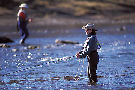
Some of the most scenic rivers and majestic lakes in America are here to enjoy. Trout floats on the White, Little Red and Spring Rivers, plus bass and panfish outings on the lakes and smaller streams, make for world-class fishing action. Recreational boating, canoeing and swimming are also on the agenda of many visitors.

Plan a leisurely walk along a trickling stream, or pick up the pace on an award-winning hiking trail. Enjoy the shady porch of a cozy log cabin or sail a 40,000-acre lake. Take time to tour a museum, historic home, formal garden or Civil War park. Dance and sing along at an informal mountain hoedown or dress up for an evening on the town.

Include a day or two to explore the rich heritage of the hill country. Study the traditional folkways, see the wonders of a limestone cavern or visit a craftsman at work.

Hideaway in the Ozarks this year.

Attractions and Upcoming Events

Rivercliff Golf Course

Rivercliff Golf Course in Bull Shoals, Arkansas is located in the natural beauty of the Ozarks. Just a few minutes from Bull Shoals Lake and some of the best trout fishing in the country, golfers of every age are welcomed to play this course. Rivercliff is an 18-hole 6382

Bull Shoals, AR Golf Courses

Mountain Village 1890

Eleven main historic structures and numerous additional outbuildings, all of which have been brought here from various sites in the Ozarks. All are authentic, as are their contents, and all were being used in 1890.

Bull Shoals, AR Historic Towns

Bull Shoals Caverns

Directions: Turn South at Harps Grocery on Ark. 178. Features formations millions of years in the making; the site has been used by prehistoric natives, Civil War soldiers and moonshiners; underground rainbow trout stream, miniature lake;

Bull Shoals, AR Caving

Top O' the Ozarks Tower

Directions: 2 miles west of Bull Shoals Dam on Hwy 178. View over a million acres after riding the smooth, quiet elevator to the top. Glass-enclosed area overlooking Bull Shoals Lake and Dam, White River and Bull Shoals-White River State Park.

Bull Shoals, AR Scenic Views

Things to do near Bull Shoals, AR

Compton Gardens

Gardens including 6.5 acres of native plants, state champion trees, streams, bridges, and walking trails; Conference Centre a...

Pivot Rock & Natural Bridge

Directions: Off U.S. Hwy. 62 West Unusual geological formations deep in forest; three block nature trail ...

Bull Shoals Lake Hunting

Hunting for white-tailed deer, eastern wild turkey, and squirrel is outstanding around Bull Shoals Lake; and opportunities fo...

Wild Wilderness Safari

Directions: Taking Ark. 59 South to Gentry.Turn right on Ark. 12 and cross the viaduct. Turn at the first road on the right (...