Jetmore, Kansas
Sawlog Mural
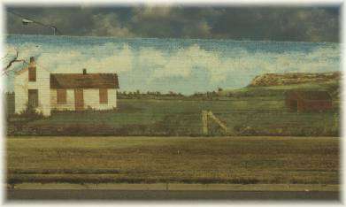 The 'point of rocks' mural is an interesting stop along Jetmore Main Street. It depicts early day farm life along the Sawlog Creek in southern Hodgeman County....
Sawlog Mural
The 'point of rocks' mural is an interesting stop along Jetmore Main Street. It depicts early day farm life along the Sawlog Creek in southern Hodgeman County.... The Point of Rocks landmark is located eight miles south of Jetmore on US 283, 6.75 miles east and 1.5 miles north. Before the settlement of the area, the 'point of rocks'
Jetmore, KS LandmarksThe Fort Hays-Fort Dodge Road is an interesting trail crossing the eastern part of Hodgeman County. The road was used to haul freight from the rail head to connect to the Santa Fe Trail, Fort Dodge and the New Mexico. The Duncan'
Jetmore, KS Historical MarkersBuckner Valley Park is located five and one-half miles west of Jetmore on Buckner Creek. The original dam site on the Buckner Creek was built through the Works Progress Administration (WPA)
Jetmore, KS RecreationJetmore City Lake, three miles west and one and one-half south of Jetmore, is located on Spring Creek. The lake is popular for camping, fishing, bird watching, boating, water skiing, beach volleyball, swimming and hiking. Rolling grassland surrounds the area with the bluffs in the background.
Jetmore, KS RecreationThe brochure outlines a self-guided walking and/or driving tour of historic sites in Dodge City, The Santa Fe Trail and Fort ...
WHAT TO KNOW ABOUT ACCURATE FISHING REPORTS: This is just to remind you that fishing reports are given with the bes...