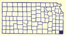
Cherokee County, KS
 Cherokee County is located in the territory that was part of the Louisiana Purchase in 1803. The area was then set out as the 'Neutral Lands" in a treaty with the Osage Indians in 1825. This 25 miles east- west by 50 miles north-south on the west of the Missouri border and east of the Osage Reservation was to be a buffer zone. Hunting, fishing, mineral extraction were allowed with no settlement of either white or Indians.
When the Cherokee Nation was relocated to the west from Georgia in 1835 they wanted more land. The Federal Government purchased from the Osage this 800,000 acres which then became known as the "Cherokee Neutral Lands".
The Kansas Territorial Legislature included the area in the setting of boundaries of the state in 1855. The southern boundary was to be at the 37th parallel and the area was named McGee County in 1860. Upon Kansas Statehood, January 29,1861, the area was 24 miles west by 50 miles north with the name changed to Cherokee County.
During the Civil War the Cherokee Indians sided with the south and believing they had ownership of the land, sold it to the Confederacy for $250,000 in Confederacy money, plus providing two companies of soldiers. This was to present a great deal of conflict over the title to the land.
Explore Cherokee County
Columbus Museum
"A Town within a Town" A colorful look at the history of Columbus. The unique Village Street, made entirely of brick from the Columbus Metzger Brick & Tile Plant between 1880 and 1910, runs along models of early shops and businesses like the Music Shop, Doctor'
Columbus, KS MuseumsNational Cemetery #2
The soldier's plot in this cemetery was designated by the federal government after the Civil War on ground donated by the city for that purpose. It is under the jurisdiction of the National Cemetery Plot in Ft. Scott. The soldier's monument was erected in the spring of 1870
Baxter Springs, KS CemeteriesColumbus' 1880s Town Square
Take a stroll around the 1880's square of Columbus and visit our shops. You must not miss the turn of the century architecture, or the unique color schemes of each building. Tour the community and see the many historical churches and Victorian homes. Driving tour map available at Chamber office, 320
Columbus, KS Historic DowntownsAndrew Carnegie Library
The library is one of 33 Andrew Carnegie libraries in the state of Kansas. It is on the National Historic Register.
Columbus, KS Carnegie LibrariesJohnston Public Library
The grand old building was entered on the National Register of Historic Places in 1976. Built in 1872, it was intended to be the County Courthouse, but was never used for that purpose. Through the years the building has been a city hall, theater, and college. In 1905
Baxter Springs, KS Historic BuildingsLog Cabin
The log cabin was built east of the Lowell Cemetery in the 1870s. R.A. Hibbard built it as a home for his brother-in-law's family. Kent Lynch purchased the property and donated the cabin to the Historical Society in memory of Marsah Moncrief Lynch. In 1987
Baxter Springs, KS Pioneer HistoryMurals
1. " The Baxter Springs Massacre" by Edmond V. Ness is displayed inside the museum. - Historical Museum, 8th and East Avenue 2. Painted on the exterior wall of Bilke's Western Museum of the longhorn cattle drive. Artist, John Gibbons, 1991. - 11th and Military 3
Baxter Springs, KS ArtsBig Brutus
One of the most unique day trips in Southeast Kansas is to Big Brutus, 11,000,000 pounds of fun! Big Brutus is the world's second largest electric mining shovel. Walk through its cavernous body, sit in the operators chair or climb 16
Columbus, KS One Of A KindsDAR Marker
Erected by the Baxter Springs Chapter of the DAR in 1931, the marker is dedicated in Memory of Gen. James G. Blunt and his escort who, defenseless fell victims to the inhuman ferocity of guerillas, led by the infamous Quantrill in his raid upon Baxter Springs, October 6, 1863, in which 135
Baxter Springs, KS Historical MarkersBaxter Springs Historical Museum
The Baxter Springs Historical Museum is filled with exhibits depicting the various stages of the city'
Baxter Springs, KS MuseumsColumbus Wye and Frisco Caboose
The Columbus Wye is a one of its kind three way switch allowing trains to turn around. The crossing, formerly located in the northern part of Columbus was donated to the City of Columbus by the Burlington Northern Railroad. At the time the switch was constructed, it was one of the three built:
Columbus, KS Railroad HistoryBlack Dog Trail Marker
Located on the grounds of the Historical Museum, the marker commemorates the Black Dog Trail opened in 1803 by Chief Black Dog ( Manka - Chonka) and his band of Osage Indians who had a village nearby where springs once flowed freely.
Baxter Springs, KS Historical Markers