Hodgeman County, KS
 In 1868, seven years after Kansas became a state, Hodgeman County was created by an act of legislature. However the county was not formally organized until 1879. It was named in honor of Captain Amos Hodgman, Seventh Cavalry officer. The discrepancy in the spelling of the name is due to a typographical error that was never corrected.
Many of the brave and most feared men in the 7th regiment were in Hodgeman's Company. It became one of the more famous Companies, the 7th Calvalry was later led by Gen. Custer in the Battle of Little Big Horn, and Captain Hodgeman became known for his extreme bravery. The quiet talking, rarely smiling Captain Hodgeman, died on the field of battle, October 10, 1863, while leading a charge against rebels, near Wyatt, Mississippi. His death was much less noticed than the death of one of his more famous fighting companions, "Buffalo Bill" Cody.
The first land claim was made by John O'Loughlin, a former soldier who hailed from Fort Hays. He established a toll bridge over the Pawnee in the north-eastern part of the county, and began selling supplies to freighters running a route from Fort Hays and Ellsworth to Fort Dodge. O'Loughlin sold out to George Duncan and the spot became known as the Duncan Crossing. A monument, dedicated with considerable ceremony in 1929, marks this site.
Explore Hodgeman County
Fort Hays-Fort Dodge Road
The Fort Hays-Fort Dodge Road is an interesting trail crossing the eastern part of Hodgeman County. The road was used to haul freight from the rail head to connect to the Santa Fe Trail, Fort Dodge and the New Mexico. The Duncan'
Jetmore, KS Historical MarkersJetmore Motorplex Inc.
Bombers, Cruisers, Modifieds, Sprint, Super Stocks, Go-Karts, Midgets, Flat Track Motorcycles - NCRA, KORR, SMRS/RMMRA, ASCS 360, TORA LM - National Championships
Jetmore, KS Car RacesPoint of Rocks Prairie Landmark
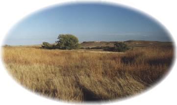
The Point of Rocks landmark is located eight miles south of Jetmore on US 283, 6.75 miles east and 1.5 miles north. Before the settlement of the area, the 'point of rocks'
Jetmore, KS LandmarksBuckner Valley Park
Buckner Valley Park is located five and one-half miles west of Jetmore on Buckner Creek. The original dam site on the Buckner Creek was built through the Works Progress Administration (WPA)
Jetmore, KS RecreationHaun Museum
The Haun Museum is located in the first house on the townsite of Jetmore. Listed on the National Register of Historic Places, it was built in 1879, by T.S. Haun, the founder of Jetmore, then called Buckner. Mr. Haun edited the first newspaper in Jetmore, The Buckner Independent
Jetmore, KS MuseumsHodgeman State Lake & Wildlife Area
Hodgeman State Lake & Wildlife Area is located 4 miles east of Jetmore on Highway 156, then 2 miles south. The State Lake measures 87 acres, which are periodically dry. When water is present the lake is stocked. The Wildlife Area encompasses 254
Jetmore, KS RecreationJetmore City Lake
Jetmore City Lake, three miles west and one and one-half south of Jetmore, is located on Spring Creek. The lake is popular for camping, fishing, bird watching, boating, water skiing, beach volleyball, swimming and hiking. Rolling grassland surrounds the area with the bluffs in the background.
Jetmore, KS RecreationJetmore Country Club
Course Access: Private
Holes: 9
Reserve Advance Tee Times: