Woods County, OK
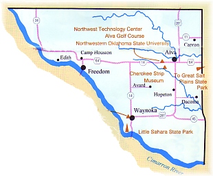 Woods County is located two counties east of the Oklahoma panhandle along the northern border of the state with the Cimmaron River forming it's southern border making it easily recognizable as being triangular in shape.
At the western edge of the county you'll want to visit the bigger-than-life community of Freedom where the cedar-fronted buildings on Main street create the appearance of an early frontier community. The town celebrates its Western heritage every August during the Freedom Rodeo & Old Cowhand Reunion - thousands of authentic and would-be cowboys from across the state attend yearly.
In Waynoka you can rent a six-man dune buggy and driver to cruise the sands of 1,800-acre Little Sahara State Park. All kinds of off-road vehicles are welcome here, and there are campgrounds for overnight trips.
Alva, the county seat of Woods County, is proud to be the home of Northwester Oklahoma State University and enjoys the diverse programs offered throughout the year. The Cherokee Strip Museum displays historical exhibits about the Cherokee Outlet as well as German artifacts from a POW camp south of town.
Cherokee Outlet history .
Much of its history is bound to the opening and closing of the Cherokee Outlet. The Treaty of New Echota (Georgia) in 1835, assured the Cherokee Nation of a "perceptual outlet west, and a free and unmolested use of all the county west of...said seven million acres." thus the Cherokee outlet was created. It was to serve as an "outlet" to their hunting grounds. The Cherokee Outlet is commonly, but wrongly, referred to as the Cherokee Strip. The Cherokee Strip is a strip of ground 2.46 miles wide, all in Kansas, that runs from the Neosho River on the east of the 100th meridian on the west. it was created due to a misunderstanding in the surveying of Osage lands in Kansas. The Cherokee Outlet is rectangular in shape and is 58 miles wide and 222 miles long, containing approximately 8,240,000 acres.
After the Civil War, when the cattle drives began, the cattlemen found the Outlet a good place to graze and keep the cattle on their way to market. In 1883, a Cherokee Strip Livestock Association was officially incorporated to deal with the Indians. This resulted in a five year lease with the Cherokees for $100,000 which was renewed in 1888 for $200,000. however, On February 17, 1890, President Benjamin Harrison issued a proclamation forbidding further introduction of cattle into the Outlet and ordering the removal of all cattle, buildings and fences before October , 1890, a deadline later extended to December 1, 1890. Apparently, sometime after this and before the "run," the entire Outlet was fenced to keep cattle out of the Outlet. The preferred barbed wire was, apparently, Scott's Arrow Plate, some of which may still be found in fences on the Kansas-Oklahoma border.
By 1890, the Outlet had been surveyed and divided into counties given the designations of K,L,M,N,O,P,and Q. The people were allowed to choose the name at the first general election held November 6, 1894. The Republicans chose the name Flynn. The Democrats chose the name Banner. The Populists won the election and chose the name Wood after a noted Kansas pioneer, Colonel Sam N. Wood. Through a clerical error the name was recorded as "Woods" instead of "Wood."
Explore Woods County
World War II POW Camp
A World War II POW Camp was located just south of Alva in the 1940s. More than 5,000 prisoners were interned at a time when the population of Alva itself was only 3,500.
Alva, OK Military HistoryHistoric Churches
The Alva Friends Church was established in 1901 and located at this spot in 1919 as Alva's first Church. The Fire Bell was Fire Bellplaced in this church in Wichita, Kansas, in 1893, and was moved to Alva, Oklahoma, in 1895.
Alva, OK Historic ChurchesFreedom Rodeo
Freedom's "pride and joy" is its annual rodeo held on the third weekend of August. Billed as "The Biggest Open Rodeo in the West," it has been drawing fans and contestants from all across the nation for 50
Freedom, OK RodeosOutdoor Murals
The Cherokee Strip Land Run - Robert Cooke, 1998 Northwest wall at 6th and College
Alva, OK ArtsThe Freedom Museum
The Freedom Museum is one of the most popular places of interest in this area. The museum houses one of the most extensive collections of late 1800s and early 1900
Freedom, OK MuseumsAlabaster Caverns
Almost everyone is intrigued with caves. We love to explore them and talk about what might have happened in them hundreds of years ago or what might live in them now.
Freedom, OK Natural AttractionsCherokee Strip Museum
In 1975 the Cherokee Strip Museum Association acquired the former Alva City Hospital building with its 40 rooms to house one of Oklahoma's best collections of pioneer exhibits. Several of the rooms are set up to display specific period artifacts. * Gun Room * Hat Room * Drug Store *
Alva, OK MuseumsOld Jail and "Boot Hill"
Keeping with the theme of the "Old West," the Old Jail is still standing to accommodate those rowdy cowhands who might get a little out of hand during the Big Rodeo celebrations. Located just to the right of the jail is a partial of land reserved for the fellas who weren'
Freedom, OKOld Cowhands Reunion
This ongoing tradition began way back in the year 1939, when members of the Freedom Chamber of Commerce decided to sponsor a reunion and chuck wagon feed in honor of the old time cowhands of this vast area who braved the perils and hardships of the range in search of their fortune.
Freedom, OK Festivals