Four Corner Survey Marker
category : Historical Markers
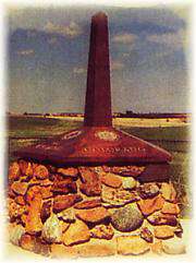 The Kansas-Nebraska Act of May 30, 1854, created the territories of Nebraska and Kansas, which had to be surveyed before settlement of the prairies could proceed. On May 8, 1855, Charles A. Manners set a cast-iron monument on the bluff west of the Missouri river at 40-degrees north latitude. In 1855-1856, Manners surveyed westward, from the cast iron monument 108 miles establishing the base-line, which is the boundary between Kansas and Nebraska and the Initial Point of the Sixth-Principal Meridian. This Initial Point, a red sandstone which lies under a manhole cover controls the system of sections, townships and ranges of the public land surveys in Nebraska, Kansas and parts of Colorado, Wyoming and South Dakota. This Initial Point is referenced in all ownership records throughout the system. On June 11, 1987, the Professional Surveyors of the Sixth-P.M. dedicated the memorial.
This historic marker is located one mile west and one mile north of Mahaska, Kansas.
Come visit us in Nebraska, Nebraska