Arkansas Recreation
Mulberry River
Considered one of the state'
Ozark Lake
As the Arkansas River flows through the state, it reaches its northern-most point in a sweeping bend. Now a part of Ozark Lake, this big bend was called "Aux Arc"
Cove Lake
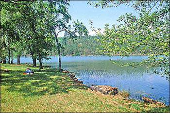
In the Ozark National Forest, 160-acre scenic Cove Lake features swimming, hiking, camping, and fishing. There are 28 family-unit campsites, 24
Lake Beaverfork
Lake Beaverfork lies along the east side of Ark. 25
Lake Conway
The largest Game and Fish Commission lake in the country at 6,700 acres; popular for catfish, bream and bass fishing.
Lake Maumelle
Directions: Located west of Little Rock off Ark. 10 Popular for fishing, sailing regattas, and boating; no swimming allowed.
Bald Knob Lake
Bald Knob Lake was built in 1960 as a 217-acre reservoir for the city waterworks. Bass, crappie, bream and catfish are popular catches. The lake is restricted to 10
Bear Creek Lake
The 625-acre Bear Creek Lake was constructed atop Crowley's Ridge in east central Arkansas in 1938
Craighead Forest Lake
Craighead Forest Lake is an 80-acre recreational impoundment located south of Jonesboro on Crowley's Ridge. The lake serves as the focal point of the area'
Mallard Lake
Gained national attention when a 16 lb. 4-ounce largemouth bass was caught here, still a state record; boat ramps, wheelchair accessible fishing pier;
Shady Lake
Food Service/Picnic Area Available Directions: Five miles southwest of Glenwood on U.S. 70; west 23 miles on Hwy. 84 to Athens, then 2 miles west on Hwy. 246. Then north at sign for 3
Bull Shoals Lake
Created by one of the largest concrete dams in the nation, Bull Shoals covers 45,000 acres with a 1,000-mile shoreline. Famous for its largemouth and striped bass; several state records including a 53
Norfork Lake
Granddaddy of all the big Ozark lakes. A 550-mile shoreline offers a wide choice of resort accommodations and the action is non-stop for bass, walleye, stripers and panfish; scuba diving; 12
Beaver Lake
28,000
War Eagle Cavern on Beaver Lake
Credit Cards Accepted: MasterCard, Other cards accepted, Visa Food Service/Picnic Area Available Directions: Located on Scenic Ark. 12 halfway between Rogers and Eureka Springs
Little Red River
The Little Red emerges icy-cold from beneath Greers Ferry Dam near Heber Springs. "Rip" Collins proved that this is a premier-class trout stream in 1992 when he landed a world-record 40
Greers Ferry Lake
Nestled in the Ozark foothills between Clinton and Heber Springs, Greers Ferry is among the state'
Lake Columbia
Food Service/Picnic Area Available On Lake/River Name of Lake/River: Lake Columbia Directions: South From Magnolia On Hwy 371, 4 Miles, Turn Right On Hwy 344, 4 Miles; Left On County Road 53, 3
Lake Monticello
A 1,520
Cane Creek Lake

The 1,700-acre Cane Creek Lake was completed in 1987 southeast of Star City as a cooperative project between the Arkansas Game and Fish Commission (AGFC)
Cane Creek Lake
The 1,700-acre Cane Creek Lake was completed in 1987 southeast of Star City as a cooperative project between the Arkansas Game and Fish Commission (AGFC)