Altus, Oklahoma
-
17miles North of Altus25miles Northeast of Altus
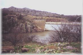 Tom Steed Reservoir, with 6,400 surface acres and 31 miles of shoreline, lies on West Otter Creek northeast of Altus in Kiowa County.
... continue
Tom Steed Reservoir, with 6,400 surface acres and 31 miles of shoreline, lies on West Otter Creek northeast of Altus in Kiowa County.
... continue
Attractions and Upcoming Events
Western Oklahoma State College
Western Oklahoma State College, established as Altus Junior College in 1926, is the oldest continuing two year college in Oklahoma. An emphasis in academic transfer and more than 59
Altus, OK Colleges
Crossing the Red
The "Crossing the Red" statue depicts a cattle drover herding cattle across the Red River which flows just 30 miles south of Altus along the Oklahoma /
Altus, OK Arts
Museum of the Western Prairie
The Museum of the Western Prairie examines the development of Southwest Oklahoma, the geographic area bounded by the North Fork of the Red River, the 100th Meridian and the Red River. The area, organized in 1873
Altus, OK Museums
Things to do near Altus, OK
Sandy Sanders Wildlife Management Area
The Sandy Sanders WMA covers 16,510 acres of Greer and Beckham counties in Southwest Oklahoma.The...
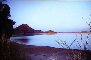 Altus Reservoir, with 6,260 acre surface acres and 49...