Jetmore, Kansas
Sawlog Mural
 The 'point of rocks' mural is an interesting stop along Jetmore Main Street. It depicts early day farm life along the Sawlog Creek in southern Hodgeman County....
Sawlog Mural
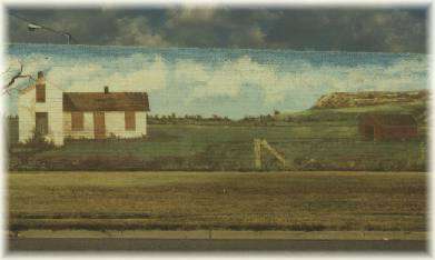
The 'point of rocks' mural is an interesting stop along Jetmore Main Street. It depicts early day farm life along the Sawlog Creek in southern Hodgeman County.... The Point of Rocks landmark is located eight miles south of Jetmore on US 283, 6.75 miles east and 1.5 miles north. Before the settlement of the area, the 'point of rocks'
Jetmore, KS LandmarksHodgeman State Lake & Wildlife Area is located 4 miles east of Jetmore on Highway 156, then 2 miles south. The State Lake measures 87 acres, which are periodically dry. When water is present the lake is stocked. The Wildlife Area encompasses 254
Jetmore, KS RecreationBuckner Valley Park is located five and one-half miles west of Jetmore on Buckner Creek. The original dam site on the Buckner Creek was built through the Works Progress Administration (WPA)
Jetmore, KS RecreationJetmore City Lake, three miles west and one and one-half south of Jetmore, is located on Spring Creek. The lake is popular for camping, fishing, bird watching, boating, water skiing, beach volleyball, swimming and hiking. Rolling grassland surrounds the area with the bluffs in the background.
Jetmore, KS Recreation