Arkansas Area Lakes and Reservoirs
-
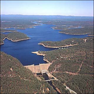
Beaver Lake
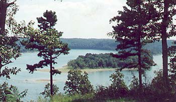 Beaver Lake, nestled high in the Northwest Arkansas' Ozark Mountains has 487 miles of shoreline and covers nearly 30,000 surface acres. Fed by the White River, the lake is Arkansas' premier recreational and sporting lake.
The lake is administered by the U.S. Army Corps of Engineers. The Corps
... Beaver Lake
Beaver Lake, nestled high in the Northwest Arkansas' Ozark Mountains has 487 miles of shoreline and covers nearly 30,000 surface acres. Fed by the White River, the lake is Arkansas' premier recreational and sporting lake.
The lake is administered by the U.S. Army Corps of Engineers. The Corps
... Beaver Lake
-
Blue Mountain Lake
Blue Mountain Lake is located in the shadow of Mt. Magazine, Arkansas' highest mountain. Blue Mountain Lake has offered many recreational opportunities since its completion in 1947. Modern campgrounds (Waveland and Outlet Parks) provide tent and trailer spaces, electrical and water hookups, ... Blue Mountain Lake -
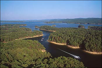
Bull Shoals Lake
 The largest of the Ozark Twin Lakes, Bull Shoals Lake is a favorite family, fishing, and group vacation destination in Arkansas. Created by damming the White River, this magnificent body of clear blue water is surrounded by 1,000 miles of beautiful mountain shoreline. Glass smooth surfaces make
... Bull Shoals Lake
The largest of the Ozark Twin Lakes, Bull Shoals Lake is a favorite family, fishing, and group vacation destination in Arkansas. Created by damming the White River, this magnificent body of clear blue water is surrounded by 1,000 miles of beautiful mountain shoreline. Glass smooth surfaces make
... Bull Shoals Lake
-
DeGray Lake
 As evidenced by its popularity for fishing, camping, swimming, water-skiing and other water sports, the 13,400-acre DeGray Lake is a prime vacation and weekend getaway in west-central Arkansas. Situated among ridges of the Ouachita Mountains and formed by a dam across the Caddo River, the lake has
... DeGray Lake
As evidenced by its popularity for fishing, camping, swimming, water-skiing and other water sports, the 13,400-acre DeGray Lake is a prime vacation and weekend getaway in west-central Arkansas. Situated among ridges of the Ouachita Mountains and formed by a dam across the Caddo River, the lake has
... DeGray Lake
-
DeQueen Lake
DeQueen Lake was created following the 1977 completion of a dam on the Rolling Fork River. Its surface covers 1,680 acres with a shoreline length of 32 miles. U.S. Army Corps of Engineers' recreation areas on the lake offer 110 campsites, boat ramps, swimming areas, fish-cleaning stations, picnic ... DeQueen Lake -
Dierks Lake
Dierks Lake was formed after the 1975 completion by the U.S. Army Corps of Engineers of a dam across the Saline River in southwestern Arkansas. Located on the 1,360-acre lake are Corps' of Engineers' recreation areas offering more than 100 campsites, boat ramps and swimming areas. The lake is ... Dierks Lake -
Gillham Lake
Gillham Lake was created in Southwest Arkansas following the 1975 completion of a dam on the Cossatot River. The 1,370-acre reservoir, located in Howard and Polk counties, features U.S. Army Corps of Engineers' recreation areas that include some 70 campsites, boat ramps, swimming areas, picnic ... Gillham Lake -
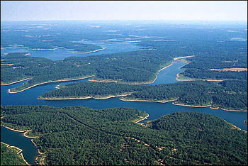
Greers Ferry Lake
 One of the Arkansas Ozarks favorite watery playgrounds is Greers Ferry Lake, located in the north-central portion of the state. With 40,000 acres of lake surface to accommodate both boaters and fishermen, the fishing at the lake is superb throughout the year. Greers Ferry Lake offers great
... Greers Ferry Lake
One of the Arkansas Ozarks favorite watery playgrounds is Greers Ferry Lake, located in the north-central portion of the state. With 40,000 acres of lake surface to accommodate both boaters and fishermen, the fishing at the lake is superb throughout the year. Greers Ferry Lake offers great
... Greers Ferry Lake
-
Lake Columbia
Lake Columbia is a 3,000-acre impoundment stretching for six miles along Beech Creek. It was constructed in 1986 by the Arkansas Game and Fish Commission, which provides three concrete boat ramps, two with accompanying courtesy boat docks and fishing piers accessible to persons with handicaps. A ... Lake Columbia -
Lake Greeson
 Narrows Dam impounds the waters of the Little Missouri River to form 7,000-acre Lake Greeson, a prime recreational resource in southwest Arkansas. The 12-mile-long lake features clear waters and steep, rocky ridges that form numerous islands and long peninsulas extending into the lake. Anglers
... Lake Greeson
Narrows Dam impounds the waters of the Little Missouri River to form 7,000-acre Lake Greeson, a prime recreational resource in southwest Arkansas. The 12-mile-long lake features clear waters and steep, rocky ridges that form numerous islands and long peninsulas extending into the lake. Anglers
... Lake Greeson
-
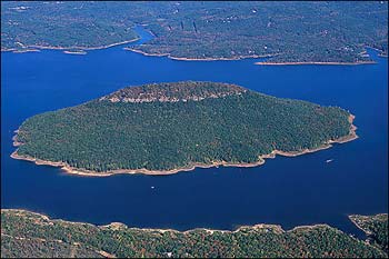
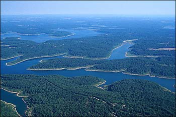
Lake Ouachita
 Lake Ouachita, the largest lake (40,100 acres) located entirely within Arkansas, is renowned for its scenic beauty and clear waters. Created when Blakely Mountain Dam impounded the waters of the Ouachita River near Hot Springs, the lake is virtually surrounded by the Ouachita National Forest and
... Lake Ouachita
Lake Ouachita, the largest lake (40,100 acres) located entirely within Arkansas, is renowned for its scenic beauty and clear waters. Created when Blakely Mountain Dam impounded the waters of the Ouachita River near Hot Springs, the lake is virtually surrounded by the Ouachita National Forest and
... Lake Ouachita
-
Millwood Lake
Millwood Lake in southwest Arkansas was formed when the state's longest earthen dam (3.33 miles) was completed across the Little River. Millwood is a renowned fishing lake, with much of its more than 29,000 acres being flooded timber that provides exceptional cover for its wide variety of fish, ... Millwood Lake -
Nimrod Lake
 The 3,550-acre Lake Nimrod is Arkansas's oldest lake created by the U.S. Army Corps of Engineers. It was formed following the 1942 completion of a dam on the Fourche LaFave River. The Ouachita National Forest borders the lake's south shore, and State Scenic 7 Byway passes by its east end.
Nimrod
... Nimrod Lake
The 3,550-acre Lake Nimrod is Arkansas's oldest lake created by the U.S. Army Corps of Engineers. It was formed following the 1942 completion of a dam on the Fourche LaFave River. The Ouachita National Forest borders the lake's south shore, and State Scenic 7 Byway passes by its east end.
Nimrod
... Nimrod Lake
-
Norfork Lake
 Norfork Lake has more than 550 miles of shoreline and covers some 22,000 acres. There are 19 developed parks that provide plenty of opportunities for camping and for water sports. Boating, water skiing, diving and swimming are all extremely popular on the lake. Commercial docks on the lake have
... Norfork Lake
Norfork Lake has more than 550 miles of shoreline and covers some 22,000 acres. There are 19 developed parks that provide plenty of opportunities for camping and for water sports. Boating, water skiing, diving and swimming are all extremely popular on the lake. Commercial docks on the lake have
... Norfork Lake
-
Ozark Lake
Ozark Lake is a major unit in the multiple-purpose plan of development of the Arkansas River and tributaries, known as the McClellan-Kerr Arkansas River Navigation System. Ozark Lake covers 10,600 acres of water area and a land area of 6,349 acres surrounds the lake and extends around the shoreline ... Ozark Lake