Vulture Peak
category : Hiking Trails
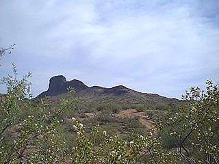 Vulture Peak Trail is a short but steep trail that takes hikers from the base of Vulture Peak (2,480 feet) to a saddle (3,420 feet) just below the summit in only two miles. From this point, experienced hikers can "scramble" up an extremely steep and narrow "chute" to the summit of Vulture Peak itself (3,660 feet). The final ascent is not maintained and should be attempted only by experienced and well conditioned hikers.
Vulture Peak Trail receives the greatest use in October-April. Drinking water is not provided. You may encounter rattlesnakes or other poisonous creatures. watch for them and be careful where you put your hands and feet. Keep pets leashed.
A Chamber produced hiking guide details parking and trail information for Vulture Peak and other hiking destinations. Certificates are given by the Wickenburg Chamber of Commerce upon completion of the Vulture Peak Trail.
Address: 7 miles south of Wickenburg
Phone: 928-684-5479
DIRECTIONS - From Wickenburg, proceed West on Highway 60 and turn left on Vulture Mine Road. About 3.5 miles beyond the turn, Vulture Peak Road comes in on your left, do not take Vulture Peak Road as it dead ends on the east side of Vulture Peal. Continue on Vulture Mine Road another 32. iles - look for the windmill on the right after a long curve to the right - turn left onto the dirt road almost opposite the windmill. Proceed as far as you feel confortable in your vehicle. For two-wheel drive cars this will be about 3/4 of a mile. Park and walk or hike anywhere in this area. The land is publicly owned and therefore open to the public. Private property will be posted with no trespassing signs.
Come visit us in Arizona, Arizona