Big Bend National Park Trails
category : Hiking
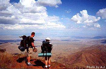 Big Bend National park is a hiker's paradise containing the largest expanse of roadless public lands in Texas. More than 150 miles of trails offer opportunities for day hikes or backpacking trips.
Elevations range from 1,800 feet at the eastern end of Boquillas Canyon to 7,825 feet atop Emory Peak in the Chisos Mountains. These elevation changes produce an exceptional variety of plants, animals, and scenic vistas.
About 30 miles of park trails are developed and heavily used. These include short nature trails and the trails in the Chisos Mountains. Most other trails are primitive, difficult to follow, and in some instances no more than a route up a dry wash.
EAST SIDE OF THE PARK
Panther Junction to Rio Grande Village
Rio Grande Village Nature Trail - 3/4 mile roundtrip
Although a very short and easy trail, the RGV Nature Trail is very scenic and offers fantastic opportunities for wildlife viewing, especially birds. A self-guiding leaflet describes the area's natural and human history. Pick up the trailhead behind RGV campground site #18. After crossing a boardwalk through a spring-fed wetland, the trail gradually ascends a small limestone hill. A side trail leads to the banks of the Rio Grande. From trail's end, hikers are rewarded by a magnificent panorama of the Sierra del Carmen, the river floodplain, Boquillas, Hot Springs Canyon, and the Chisos Mountains. This is probably the best sunset view in the entire park.
Boquillas Canyon - 1.4 miles roundtrip
From the parking area at the end of the Boquillas Canyon Road, the trail climbs over a low limestone hill and drops to the banks of the Rio Grande near some Indian mortar holes. Hikers enjoy great views of the river and mouth of Boquillas Canyon. Further down the trail is a huge pile of wind driven sand below a shallow cave.
Ernst Tinaja - 1.4 miles roundtrip
A short walk up a sandy wash leads to a canyon of highly-convoluted rock layers. The large natural tinaja holds water all year long. Be careful near the tinaja's edge. Over the years deer, javelina, and even mountain lions have been found drowned in this tinaja. The trailhead is located off the Old Ore Road, 5 miles from the southern end near Rio Grande Village. High clearance vehicles are necessary to reach this enjoyable trail. A primitive campsite is located near the trailhead.
Pine Canyon - 4 miles roundtrip
This beautiful hike begins at the very end of the Pine Canyon primitive road. A high-clearance vehicle is necessary to reach the trailhead. The trail gradually climbs through open desert grasslands for one mile before entering the actual canyon. Once in the shelter of the canyon, hikers are rewarded by a shady woodland comprised of Pinyon and Ponderosa pine, oaks, maple, and Texas madrone. The trail ends at the base of a 200-foot cliff that becomes a dramatic waterfall after any rain.
Ore Terminal Trail - 8 miles roundtrip
This strenuous day hike leads through rugged limestone desert following the remains of a 6-mile long ore tramway that once carried ore from the Mexican mines to a large terminal structure in the Ernst Basin. This is NOT a trail to hike during the summer months. This trail begins at the same trailhead as the Marufo Vega Trail. After one mile up the wash, the Ore Terminal Trail veers to the left and heads up the hillside. You will see the remains of the tram towers and cables. The trail ascends the hillside, veers around the head of a deep canyon, and generally follows the tram route to the old wooden tramway terminal in the Ernst Basin. .
Marufo Vega Trail - 14 miles roundtrip
For hikers searching for solitude and a longer loop trip, the Marufo Vega trail provides a strenuous but spectacular journey through the rugged limestone of the Dead Horse Mountains to the banks of the Rio Grande. This trail has NO WATER and is NOT recommended during the summer months when the heat is unbearable. From the trailhead along the Boquillas Canyon road, this trail heads 1 mile up a sandy wash and then turns sharply up a high limestone ridge to the east. After 3 more miles, the trail splits into two forks. The north fork descends for two miles to the Rio Grande. The south fork crosses another high ridge and after 3 miles also descends to the river through a steep 800 foot canyon. Between the two forks, a trail parallels the river from high above.
Be sure to watch for trail markers, carry a good map and plenty of water whenever hiking this rugged yet spectacular trail.
WEST SIDE OF THE PARK
Panther Junction to Castolon
Mule Ears Spring - 3.8 miles roundtrip
This trail starts at the Mule Ears Overlook parking area at milepost 15 on the Ross Maxwell Scenic Drive. Always in sight of the prominent "mule ears" peaks, the trail crosses several arroyos before reaching the spring. A rock corral and cottonwood trees mark the end. Fantastic geology and spring wildflowers make this a delightful day hike.
Santa Elena Canyon - 1.7 miles roundtrip
This trail begins at the end of the Ross Maxwell Scenic Drive. Although a short trail, it is one of the grandest spectacles in the park. After crossing Terlingua Creek, the trail climbs several short switchbacks and then gradually descends along the banks of the Rio Grande. Hikers are surrounded by lush riparian vegetation and 1,500-foot towering vertical cliffs of solid limestone. The trail ends where canyon walls meet the river. Take a lunch and enjoy the scene.
The Chimneys - 4.8 miles roundtrip
A relatively easy hike to a series of prominent volcanic dike formations in the scenic western end of the park. The "chimneys" have always been an important landmark and Indian rock art can be found along the base of these high pinnacles. The trailhead is well-marked along the Ross Maxwell Scenic Drive 1.2 miles south of the Burro Mesa Pour-off spur road. The chimneys are easily seen from the trailhead and can be reached by hiking 2.4 miles. The trail actually continues west for another 4.6 miles to a point near Luna's jacal on the Old Maverick Road. This would be an enjoyable 7 mile hike if you can arrange transportation on the opposite end. From the chimneys you can also head northwest 1.5 miles to the huge cottonwood tree that marks Red Ass Spring. Return the way you came.
Top of Burro Mesa Pour-off - 3.6 miles roundtrip - day use only
An awesome primitive trail that winds through a narrow, rocky gorge to the very top of the Burro Mesa Pouroff. From the trailhead 6.9 miles south on the Ross Maxwell Scenic Drive, the trail gradually descends into the narrow ravine. You will have to scramble over some rocks, but most of the trail is through soft sand. At the end, explore the sandy pothole cave carved by flash floods. A narrow slot in the cave wall is the top of the 100' pouroff. Do not attempt this hike during stormy weather. Make sure you follow the route carefully and return the way you came.
Ward Spring - 3.6 miles roundtrip
A pleasant desert hike leading to a tiny backcountry spring. Enjoy the great desert views and interesting vegetation. The trailhead is along the Ross Maxwell Scenic Drive at mile marker 5.5. From the trailhead you can see where a large volcanic dike dips into the canyon...this is the location of Ward Spring. You may see a hint of green vegetation hinting at its location. This spring was used by the Homer Wilson Ranch and the trail follows an old pipeline. Water is usually present most of the year.
Red Rocks (Blue Creek) Canyon - 3 miles roundtrip
A hike up a large canyon, past an old ranching property, to some of the most colorful rock formations in Big Bend National Park. Begin at the Homer Wilson (Blue Creek) Ranch Overlook, along the Ross Maxwell Scenic Drive. From the trailhead you will see the restored bunkhouse, and up-canyon, some of the "red rocks". The trail takes you up the canyon through soft gravel and sand to a series of highly eroded formations of volcanic tuff. The bright colors of red, pink, and yellow are spectacular. This trail continues to climb steeply up the canyon for 5.7 miles into the High Chisos and Laguna Meadow.
Grapevine Hills - 2.2 miles roundtrip
An easy hike up a sandy wash surrounded by massive boulders. After 1 mile the trail ascends to a low saddle at the end of the drainage. Follow the signs to locate the giant "window" of boulders. This is one of the most picturesque spots in all of Big Bend NP. Kids love this trail! The trailhead is located 7 miles down the Grapevine Hills Primitive Road. Ask a ranger about current road conditions.
CENTER OF THE PARK
Chisos Mountains Trails
The Lost Mine Trail - 5.2 miles roundtrip
This moderately difficult trail begins at mile marker 5 along the Basin Road. With it's accompanying trail guide (available at the trailhead), this is an excellent introduction to the plants and animals of the Chisos Mountains. The trail starts at an elevation of 5,600' and steadily climbs to the top of a 6,850' promontory overlooking Pine and Juniper Canyons. If you don't want to hike the whole way, one of Big Bend's greatest viewpoints is at the end of the first mile. Take a lunch and enjoy the sights and sounds of the High Chisos.
The Window Trail - 4 miles roundtrip
This trail begins from the Basin Campground near site #52. This trail is unique in Big Bend in that it descends 800 feet from the trailhead for two miles. Hikers then must gradually ascend on the way back. The first mile is through open scrub vegetation with fantastic views of surrounding Chisos peaks. The last mile enters a cool shady canyon with oaks, wildflowers, and a sometimes a trickle of water. At the end of the trail is the "window"...the pour-off that drains the entire Chisos Basin. It is a narrow slot in the canyon wall at the top of a 100 foot dropoff. This trail is a good one for viewing wildlife. Hikers frequently see javelina, gray fox, and sometimes even black bears. For an extra treat, take the Oak Spring Trail which veers off near the end of the Window Trail. Take this side trail for 1/4 mile to a point above the actual window. The panoramic view from this high vantage point is spectacular.
Emory Peak - 9 miles roundtrip
This is a 9 mile roundtrip hike to the highest point in Big Bend National Park (7,825'). The last 25 feet require a scramble up a sheer rock wall, but your reward is the ultimate panoramic view! From the Basin Trailhead take the Pinnacles trail for 3.5 miles. At this point, the one mile trail to the summit cuts off and heads upward. For fantastic views and solitude, this trail is hard to beat! Most hikers require approximately 5-6 hours for the roundtrip journey.
The South Rim - 14 miles roundtrip
The South Rim is located at the extreme southern edge of the Chisos Mountains. At the rim, the desert floor lies 2,500 feet below you and vast panoramas of rugged desert and mountains beckon far into Mexico. The South Rim can be done as a strenuous day hike, but is best enjoyed on a 1-2 night backpack trip. Backcountry campsites are available with a backcountry permit. Hikers may make a great loop by taking the Pinnacles Trail up and the Laguna Meadows Trail down, or vice versa.
NORTH END OF THE PARK
Panther Junction to Persimmon Gap
Dog Canyon - 4 miles roundtrip
This medium-difficulty trail offers a glimpse into a narrow canyon cut between massive layers of limestone. Begin this hike from the park road 3.5 miles south of the Persimmon Gap visitor center. Look for the roadside exhibit. Dog Canyon is clearly visible, yet 2 miles away. Follow the cairned trail toward the canyon. After 1.5 miles, the trail enters a wash. Turn left and follow the wash directly into Dog Canyon. Return the way you came. This hike can be very hot, especially during the summer months...be sure to bring water and a hat.
Devil's Den - 6 miles roundtrip
Explore a dramatic limestone slot canyon in the northern backcountry of Big Bend NP. Begin this hike from the park road 3.5 miles south of the Persimmon Gap visitor center. Look for the roadside exhibit. Devil's Den can be seen as a narrow cut across the mountainside to the south of Dog Canyon. Follow the cairned trail towards Dog Canyon. After 1.5 miles the trail enters a wash. Turn right here and follow the wash. After another 1/2 mile, take the large wash that intersects from the left. This will take you directly into Devil's Den. Adventurous hikers may hike into the Den for about 1/2 mile. Numerous potholes sometimes hold water. For the best views and best adventure, exit the wash at the entrance of the "Den" and follow the trail to the top along the southern edge of the deep crevice. You can then enter the den and hike back through it. Try not to get wet in the numerous small pouroffs and tinajas!
RUGGED AND REMOTE
Into the wildest places of Big Bend NP
The Mesa de Anguila
Rugged, primitive, hard to access, and spectacular
Situated along the far western boundary of Big Bend National Park, the Mesa de Anguila is rarely visited by park visitors. The mesa forms the right hand (U.S.) side of Santa Elena Canyon. It is a high uplift that extends well into Mexico. This area is for experienced hikers/backpackers only. The 7.5 minute USGS topographic map of the Mesa is essential, as are good map reading skills. The various trails are primitive and sometimes hard to follow. Water is always a problem on the mesa. Although there are several tinajas, they are frequently dry. What the Mesa de Anguila does offer is unsurpassed solitude, spectacular vistas, and magnificent desert wildness. Stop by park headquarters for more information on how to access the mesa and suggested routes.
The Outer Mountain Loop (Dodson) Trail - 30 miles roundtrip
A STRENUOUS, yet potentially very rewarding journey through some of the most rugged, remote, and beautiful landscapes of Big Bend National Park. Definitely not a hike for everybody, but for those who are prepared, an unforgettable adventure.
click here to learn more...
Map, photos, suggested itinerary, precautions, etc...
Mariscal Rim Trail - 6.6 miles roundtrip
The drive to the trailhead is long and dusty, but once you begin to hike, the spectacular views of the Rio Grande and superlative cliff walls of Mariscal Canyon will make it all worthwhile. This trail begins at the end of the Talley Road via the River Road. It will take you at least 2 hours of driving on rough dirt roads to reach the small parking area that denotes the trailhead. There are four primitive roadside campsites located along the Talley Road. Be sure to have plenty of water with you, because this hike is hot and there is NO shade anywhere along the way. The first 1.5 mile is easy and level, but the last 1.8 miles is extremely steep as it climbs straight up to the top of Mariscal Canyon. The views here are unsurpassed, and the sheer drop-off will challenge your senses.
Click here for a trail map...
Note: This trail is closed from February 1 - July 15 each year
to protect the falcons that nest on these cliffs.
Admission: $15 per vehicle or $5 per person for motorcyclists, bicyclists, or pedestrians.
Hours: Year Round
Address: Big Bend Country - Extreme SW Texas
Phone: 432-477-2251
Our Website:www.nps.gov/bibe/hiking.htm
Come visit us in , Texas