Arikaree Breaks Driving Tour
category : Tours
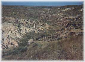 The breaks, located on the extreme northern edge of Cheyenne County, are 36 miles long and approximately two to three miles wide. This area of extremely rough terrain, with its deep ravines and gullies is a marked contrast to the plains generally associated with the area. The breaks were formed 9,000 years ago by wind deposited sand, silt and clay particles, called loess. After deposition, the loess has undergone spectacular processes of head cutting and side-wall cutting the advancing tributaries of the Arikaree River and the South Fork of the Republican River. Some of the canyons were used in days past as buffalo falls by the indigenous peoples, and one blind canyon is locally known as Horse Thief Canyon. The breaks offer stunning photographic possibilities, especially in the flat light of dawn and dusk. Enjoy a 15 Point Self-Driving Tour including 4 spring fed creeks, two caves, and breathtaking lookouts over the land referred to as The Arikaree Breaks.
Arikaree Breaks Driving Tour
1. We begin our tour at the Republican River Bridge, one mile north of the Cheyenne County Courthouse. The courthouse is ocated at Benton and Main Street. The Republican River divides the county nearly in half, flowing from southwest to northeast. t the bridge you will find the back entrance to the River Walk. The River Walk is a beautiful one mile walk paralleling the river. top, pull your car off on the turn-out and enjoy the quiet beauty.
2. At this red sign, take the right hand fork of the road. 3 G.A.R. Cemetery Turn east 1/4 mile.
3. This cemetery was established in 1889. The east half was to be used exclusively for the burial of Grand Army of the Republic Comrades and their families. The west half was to be used for the burial of citizens and their families. No lots were to be sold, only a donation for the dead was taken. This provision was made to enable destitute Civil War veterans an honorable burial.
4. Spring Creek This creek is the first of four spring fed creeks on this tour. Spring Creek was a popular homestead site for the county's early settlers.
5. Stay on the main road, heading north.
6. Plum Creek This spring fed creek has wild plums growing along its banks.
7. Cleveland Run Creek was named after the township that it is in. It was also a popular homestead site with its running spring water.
8. Hackberry Creek was the site of several Indian encampments. It is the longest of the creeks on this tour, starting one mile east of the Colorado border at the edge of the breaks.
9. Turn east here to visit Horse Thief Cave. This drive is not recommended in wet weather.
10. Continue north here to visit the breaks. Be ready for a breath taking view as the deep canyons fall away from the tabletop farm ground.
11. Lookout Point. What a breathtaking view. The breaks offer stunning photographic possibilites, especially in the flat light of dawn and dusk.
12 Down the road less than 1/4 mile from Lookout Point is a parking area. Get out of your vehicle, stretch you legs and enjoy the view.
13. Kansas-Nebraska State Line. You may continue north here, traveling to US 34, or retrace your route to St. Francis.
14. Turn north two miles east of marker number 9 to travel down a narrow winding road to see Horse Thief Cave. This is a fair weather road only.
15. Horse Thief Cave This is one of several caves in the breaks. Most of this cave has caved in over the years with only the entrance being left. This was a large two chamber cave used to hide stolen horses. The horses were kept in the large back chamber while the outlaws used the front chamber as their living quarters. This cave was last used in 1878.
Returning to sign post 9 and 10, turn south to return to St. Francis, or continue west to K-27. From there you can turn south, traveling 5 miles to the turn off to Devil's Cap another outstanding view of the breaks.
Geologically, the breaks are an exposure of three distinct geologic formations. The upper most strata is a thick mantle of tan to light brown loess, with a thickness approaching 100 feet in places. The second layer is composed of a thin remnant of the ash-gray Ogallala formation composed of sands and gravels partially cemented with calcium carbonate. The Ogallala Formation is Pliocene in age and is the main source of ground water in Cheyenne County. The lower formation is stratified, brown to yellowish-brown Pierre Shale of the late Cretaceous age. The thinly bedded Pierre Shale contains selenite crystals, bentonite seams and chalky layers.
Come visit us in St. Francis, Kansas