Cheyenne County, KS
 Cheyenne County, Kansas was named after the Cheyenne Indians, who once resided in the area. The area was surveyed in 1873, with settlement beginning in 1875. Many of today's residents can trace their families back to those first settlers.
 Cheyenne County is rich in geological and historical sites. The Breaks called by the locals a "mini Grand Canyon," is located on the northern edge of the county. The Breaks feature an extremely rough terrain of deep ravines and gullies - a marked contrast to the plains generally associated with the area. Eleven miles north of Bird City, the Round Hole Campsite memorial, marks the site used by General Custer, Colonel Bankhead and Lt. Colonel Bradley. The Cherry Creek Encampment, located two miles northwest of St. Francis memorializes the Cheyenne Indian survivors of the Sand Creek Massacre. Near Bird City, a portion of the Ancient Indian Traders' Trail is also visible. Flowing from the southwest to the northeast, The Republican River divides the county in half. The River Road parallels the river, allowing a leisurely drive with many chances to view local wildlife, including wild turkey, deer, pheasant, quail, hawks, eagles, rabbit, and beaver. The river offers numerous recreational opportunities for camping, fishing, hunting, picnicking, or a leisurely stroll down the scenic River Walk.
Explore Cheyenne County
Arikaree Breaks Driving Tour
The breaks, located on the extreme northern edge of Cheyenne County, are 36 miles long and approximately two to three miles wide. This area of extremely rough terrain, with its deep ravines and gullies is a marked contrast to the plains generally associated with the area. The breaks were formed 9,00
St. Francis, KS ToursApollo 17 Marker
St. Francis, Kansas is the birthplace and boyhood home of Apollo astronaut, Ron Evans, who was aboard the Apollo 17 in its sixth and final lunar expedition of the Apollo series in 1972. While aboard the expedition, Ron Evans made the longest space walk of the time at 44
St. Francis, KS LandmarksRiverside Recreation
Golf - 9 holes, grass greens, club house, cart rental
St. Francis, KS Golf CoursesDuckland
The park offers families a unique opportunity to picnic and observe geese, ducks, and beaver on small ponds.
St. Francis, KS ParksYe Olde Country Church
The Church was built by the First German Evangelical Lutheran Immanuel Church congregation in 1914. The original pump organ that was purchased and placed in the church in 1914
St. Francis, KS Historic ChurchesBird City Tri-State Antique Engine and Thresher Museum
This unique and thorough exhibit of Great Plains agricultural history includes 40 buildings on 40
Bird City, KS MuseumsThe Cheyenne County Museum
The museum features a diorama complete with prehistoric fossils uncovered locally. This diorama shows life as it progressed over the millenia on the High Plains, and includes furniture and period exhibits of frontier life. All of the exhibits are of Cheyenne County history.
St. Francis, KS MuseumsSawhill Park
Features one of the last bandshells in Kansas with its unique acoustics.
St. Francis, KS AmphitheatersSt. Francis City Campground
The St. Francis City Campground and Rest Area is located just adjacent and behind the Cheyenne County Museum and welcomes travelers at no charge. There are electrical hookups, drinking water, showers and restrooms, sanitary dump station, and handicapped accessible.
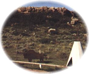
St. Francis, KS CampingCherry Creek Encampment
This site features a memorial to the Cheyenne Indian survivors of the Sand Creek Massacre on November 29, 1864. Created by a local historian and metal sculptor, Tobe Zweygardt, a teepee is guarded by an Indian brave astride his horse atop a nearby bluff. A brochure is available.
St. Francis, KS MemorialsSt. Francis GMA Sandpit and Wildlife Area
Five acres of water, camping, picnics, 480 acres of wildlife management for public hunting.
St. Francis, KS Wildlife Areas