
Santa Fe Trail
category : Pioneer History
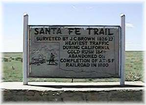 The Santa Fe Trail is thought to be the oldest and longest commercial highway across the Great Plains, from Franklin on the Missouri River east of present Kansas City nearly 800 miles southwest to Santa Fe of today's New Mexico. A direct path across the plains (the Cimarron Route or Cut-off) was used almost exclusively. Another route, the Mountain Route was used mostly by the military.
The Cimarron Route began from one of the many crossings of the Arkansas River between the lower bend of the river and Choteau's Island beyond the 101st meridian. From any of those points, it ran south westward across Kansas, the corner of southeastern Colorado and into Cimarron County of the Oklahoma Panhandle near the northeast corner. It crossed the Cimarron River at Willowbar Crossing, angled in a southwesterly direction across the county, passed near Wolf Mountain, Flag Springs, Cold Springs, Camp Nichols (Cedar Creek), and left the county near the southwest corner, close to McNees Crossing in Union County, New Mexico. In New Mexico, near present Watrous, the Cimarron Route merged with the Mountain Branch. At San Miguel it circled northwestward through Glorieta Pass to Santa Fe.
The Cimarron Route was the road to Santa Fe for wagon traffic from 1822. It was shorter and easier to travel with mule and ox drawn freight wagons and was used into the 1870's, when the railroad built into Colorado.
There are numerous sites of interest along the old trail. Tipi rings are still visible in some places, evidence of several Indian tribes who inhabited the area. There are many unusual rock formations throughout the western part of the county. Flag Springs was a major watering hole along the Trail, as well as Cold Springs, (Autograph Rock) where evidence was left in writings on sandstone cliffs by campers who chose that location to rest their wagon trains and make repairs.
It is widely believed that one of the earliest travelers on the Trail through this area known by name was the Spanish explorer, Don Francisco Vazquez de Coronado, who was searching in 1541 for Quivira. Others known to have followed portions of the trail included numerous scouts, soldiers, trappers and buffalo hunters. It was a trading route of the Kiowa, Ute, Comanche and Apache Tribes.
Camp Nichols was built under the directions of Col. Christopher (Kit) Carson, commander of the First Regiment of New Mexico Calvary Volunteers, in the spring of 1865, to guard freight and immigrant trains against hostile Indians and a band of outlaws headed by William Coe, whose headquarters were known as Robbers Roost. This was a sturdy rock hideout a few miles north of the trail. Located at Cedar Creek, Camp Nichols was abandoned by the fall of 1865. Marian Russell joined her soldier husband there, and left a good account of life at that military camp. (Her Memoirs can be found in the book "Land of Enchantment")
"Land of Enchanment" the memoirs of Marian Russell, available at the Heritage Center Museum
Come visit us in Boise City, Oklahoma